
Space monitoring and GIS for quantifying soil salinity and degradation of agricultural land in southern Kazakhstan (BR 10965172)
According to the technical assignment of the Customer in this program, the object and subject of research are saline agricultural lands of South Kazakhstan, in which the arable soil layer is at the level (0-30 cm). The scale of the required salinity maps is M 1: 300000. The relationship between the map scale and information saturation is determined by the minimum object that must be mapped (normative documentation: GOST R 51608).
Purpose of the study: The goal of the program is formulated by the Science Committee of the Republic of Kazakhstan as: “Creation of a web-based geoinformation service for operational monitoring of a quantitative assessment of the degree of soil salinity and degradation of agricultural land in the South of Kazakhstan based on data from remote sensing of the Earth. »
Research methods: Expert interpretation, standard statistical methods of correlation analysis of remotely recorded parameters (NDVI, LST, etc.) and ground information. Methods for clustering and classifying satellite data.
Scientific novelty of the results. Development of technology for quantitative assessment of the salinity of saline soils in South Kazakhstan based on ground measurements and remote sensing data of medium and high spatial resolution. Development of a methodology for assessing the degradation of agricultural land in the South of Kazakhstan based on Earth remote sensing data.
Practical and social value. Improving the social environment and improving the quality of life of the population, characterized by indicators of growth in the educational level of the population, promoting inclusive development (creating new technological solutions, developing creative industries and innovations)…
Scope and implementation of results: Salinization of irrigated land and degradation of agricultural lands in the South of Kazakhstan.
Current results:
The archives of terrestrial data on salinization of fields in the project area were formed: historical data for the period 2002-2020. (based on the materials of the Hydrogeological-reclamation expeditions of the Ministry of Agriculture of the Republic of Kazakhstan, the corresponding regions and other sources).
Own ground surveys of the salinity of irrigated arable land in the project areas were carried out, including the selection of soil samples in key areas, analysis of the salt content and an expert, ranked description of the state of agricultural fields by FAO salinity classes, as part of route surveys.
The available open archival data have been analyzed, and it has been found that in the system of the State Institution «Office of Land Relations» of the regional level, various cartographic materials are stored, dating back to the times of the former USSR (since 1972). The archives are not digitized and are kept in paper form.
Mapping the salinity of irrigated arable land encounters significant technical difficulties. A review of the scientific literature has shown that there are only separate works related to this problem. Salinization of irrigated arable land is characterized by significant variability during the season. The maps of spring and autumn salinization are of practical interest. To solve the problem of mapping the salinity of irrigated arable land in the South of Kazakhstan, the following satellite products were used:
- Vegetation index NDVI. The format of individual scenes is Sentinel-2, with a resolution of 10m. Monitoring data for the period from 2003 to the current moment (source — FEWS NET), decade update, resolution up to 250 m, in scales: absolute NDVI values; deviation from the mean; an estimate of the depth of deviation, on the scale of historically recorded variations (long-term minimum — maximum) at a given place at a given time.
- Salinity indices (selection of indices will continue). The format of individual scenes is Sentinel-2 and (or) Landsat -8 resolution (10-30 m) in the spring period (March-April).
- Sentinel-2, Landsat-8 images with resolution (10-30 m) optical channels. The format of individual scenes for assessing the spectral characteristics of the underlying surface, identifying flooding and waterlogging of irrigated arable land during the year, restoring rice crop rotations and assessing autumn-winter leaching of fields, monitoring the area of water mirrors of the main reservoirs in the region (assessing the current filling and depletion modes of reservoirs for diagnosing the water content of the season ).
- Land Surface Temperature. In the monitoring format for the period from 2003 to the present moment (source — FEWS NET), decade update, resolution 5 km; in scales: absolute values; deviation from the mean; quantitative assessment of the amount of cooling of arable land due to its irrigation (Irrigation Cooling Effect).
- Snow Depth. In the monitoring format for the period from 2001 to the present moment (source — FEWS NET), decade update, resolution 1 km
The practical significance of the described phenomenon is associated with the demand for a long-term forecast of the water content of rivers in Central Asia. The forecast of river runoff volumes affects the planning of the area under crops for various crops. The “long memory” in the long-term regime of snowiness in the highlands in the Tien Shan justifies the applicability of the simplest “inertial” forecast. At which, the snowiness of the next year is assumed to be close to the level of the current year.
In the process of carrying out research activities at this stage of the project, documentation was developed for the geoportal, a web-based geoinformation service for operational monitoring, including recommendations on architecture and software solutions for the development of a geoinformation system for quantitative assessment of soil salinity.
The work was supported by a grant from the Ministry of Education and Science of the Republic of Kazakhstan IRN BR10965172performed at the Institute of Information and Computing Technologies of the Committee for Science of the Ministry of Education and Science of the Republic of Kazakhstan, under contract No. 362 dated September 7, 2021
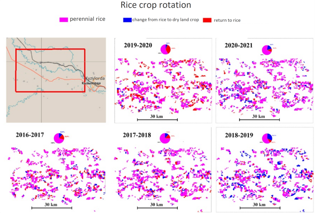


Reconstruction of rice crop rotation in the array
Publications:
- Терехов А. Г., Абаев Н. Н., Тиллакарим Т. А. Явление аномального снегопада 13–14 марта 2021 г. на юге Казахстана //Современные проблемы дистанционного зондирования Земли из космоса. – 2021. – Т. 18. – №. – С. 279-284. http://d33.infospace.ru/jr_d33/2021v18n4/279-284.pdf
- Терехов А.Г., Абаев Н.Н., Ю.А. Маглинец Спутниковый мониторинг состояния оазисов реки Амударьи в период 2003–2020 гг. на основе анализа эффекта охлаждения территорий в результате их ирригации. Современные проблемы дистанционного зондирования Земли из космоса. 2021. Т. 18. №5. С. 123–132. http://d33.infospace.ru/jr_d33/2021v18n5/123-132.pdf
- Mukhamediev R. I. et al. Review of Some Applications of Unmanned Aerial Vehicles Technology in the Resource-Rich Country //Applied Sciences. – 2021. – Т. 11. – №. 21. – С. 10171. https://doi.org/10.3390/app112110171
- Kong M. et al. Energy-efficient rescheduling with time-of-use energy cost: Application of variable neighborhood search algorithm //Computers & Industrial Engineering. – 2021. – Т. 156. – С. 107286. https://doi.org/10.1016/j.cie.2021.107286
- Мустафин С. Определение момента начала эксплуатации закладки Свидетельство о депонировании результатов интеллектуальной деятельности (РФ, СПб), № 221.018.3F64 от 21.05.2021
- Мустафин С. Автоматизированное выделение линейных объектов изображения Свидетельство о депонировании результатов интеллектуальной деятельности (РФ, СПб), № 221.018.3FBE от 03.09.2021